|
Part II: Debunking Ethiopia’s Higher Water Resources vis-à-vis Egypt: A Closer Look at the Hydrologic Outputs – Stream water Outflow
Tekleab Shibru (PhD) Associate Professor of Geomatics, Chicago State University 06-07-20 Abstract Ever since Ethiopia embarked on Grand Ethiopian Renaissance Dam (GERD), to generate electricity that would light 60% of 114 million Ethiopia’s population, Egypt has engaged in an inexorable diplomatic campaign of decrying Ethiopia’s right to use its natural resources. This rather fabricated victimhood is resonating with the larger international community given Egypt’s desertic climate. The notion that the annual average 100 mm rainfall is the only source of water for Egypt’s 100 million, if not for Nile River, is refuted in the part I of this article. This part of the article compares the Nile river basins of the two countries focusing on the portion of rainfall that is exiting the watershed through surface run-off water (i.e., stream water outflow). Accordingly, Ethiopia’s Nile river sub-basin loses 12.8 BCM of water through the Tekeze-Atbara River; 54.4 BCM of water through Blue Nile River, and 13.6 BCM of water through the Baro-Akobo-Sobat River a total of 81 BCM; while Egypt’s sub-basin is losing none. Therefore, defining Ethiopia as country with plentiful water resources, based on the rainfall data alone, without accounting the portion of the rainfall that is actually exiting the Ethiopia to drain into Egypt’s, is inconclusive. It is, therefore, about time for the international community to examine the alleged predicament with scientifically verified evidences and hold a moral ground that is fitting to the standard.
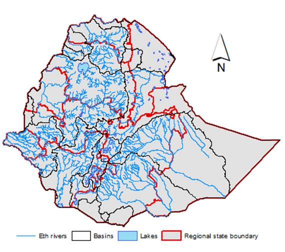
Keywords: Stream water outflow, Watershed hydrology, Water budget, Grand Ethiopian Renaissance Dam (GERD), Egypt, Ethiopia 1. Introduction In the Part I hydrologic inputs component of the overall water budget of the Nile river sub-basins in Egypt and Ethiopia was discussed. The discussion enumerated all possible sub-basins’ hydrologic inputs and exposed the flaw in the global perception of Ethiopia’s water plentiful. This article reviews, part of the other component of the water budget, stream outflow of hydrologic outputs. Hydrologic outputs, as pathways by which a particular watershed loses the water resources encompasses, stream water outflow, evaporation and transpiration. Additionally, pathways, such as groundwater recharges, subsurface outflow, evaporation from streams and water exports are also considered, though due to the lack of sufficient date, these components are omitted from consideration. The stream water outflow is water exiting sub-basins through runoffs water. Run-off is a part of rainfall water in excess of soil infiltration, direct evaporation and seepage to recharge groundwater. This excess water often flows down a landscape gradient as surface runoff. Generally, such surface run off from a landscape is a function of meteorological and bio-physical factors. Meteorologically, factors controlling run-off water are mainly rainfall amount and intensity, while the biophysical factors are topography, soils types and drainage condition, land cover, etc… Surface run off is high on a landscape experiencing intense rainfall over short time span, degraded soils with low vegetation cover, and topographies with steeply-slop gradient. Ethiopia mountainous land system exhibit a critical physical setting of both rainfall and surface run-off formation. First, the physical setting of the Ethiopia’s highland enhances orographic uplift of prevailing airmasses and the creation of torrential rainfall system, thereof. Secondly, it facilitates a condition where the torrent rainfalls coupled with the inherently rugged and sloppy landscape generate surface runoffs, which form streams or rivers upon funneled into channelized topographies carrying running water. Nightly seven percent of these streams/rivers are transboundary, and only 3% remains within the country; a phenomenon which earned Ethiopia a status of “water towers Africa” (Fig. 1).
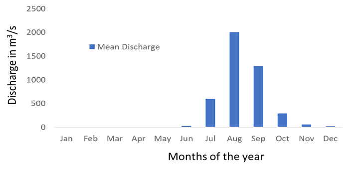
Fig. 1. Ephemeral and Perennial rivers of Ethiopia Ethiopia’s rivers are generally categorized into 4 based on their flow directions (Berhanu et al., 2014). These are westward, eastward, southward and northeast flowing rivers. Angereb, Tekeze, Mereb Abbay, Jamma, Muger, Guder, Didessa, Beles, Dabus etc… are examples of westward flowing rivers. These rivers arise from a watershed of the western Ethiopian highlands, which stretched over 39% of the country’s landmass and collecting 70% of the overall stream water resources of the country. Eastward flowing rivers are Weyb, Genale, Dawa, Wabishebele etc… and their watershed covers 33% of the country’s landmass and constitute 8% of the country’s stream water resources. The southern flowing rivers, such as Sagan, Weito. Gebe, and Gejeb are generated by the watershed covering 5% of Ethiopia’s landmass and 18% of the stream water resources. Finally, Bilate, Awash, Gidabo etc… are rivers confined to the eastern and western escarpment of the rift valley. Their watershed constitutes 10% of the county’s landmass and 4% of the streams’ held water resources. Almost all tributaries of Nile River, marking the stream water outflow, from Ethiopia’s Nile river sub-basin, are exclusively the westward flowing rivers of the western Ethiopia’s highlands. In general, there are 13 major ephemeral and perennial rivers and are coming from six of the nine regional states, namely: Tigray, Amhara, Beneshangul, Oromia, Gambella and Southern region. This is where 92% of Ethiopian population reside and only Somali, Harar and Afar regional states, where less than 8% of the population live, do not have a drop of water draining into the Nile River. The Nile feeding rivers are aggregated into three stream outflow systems right before exiting Ethiopia’s boundary, namely: The Tekeze-Atbara, Blue Nile and The Baro-Akobo-Sobat. According to Berhanu et al., (2014), these westward flowing rivers are draining 70% of the total 124.4 BCM of Ethiopia’s stream water resources. This is approximately, 87 BCM of the water in excess of rainfall received and leaving the sub-basin is a loss to the overall water budget of Ethiopia’s Nile sub-basin. Therefore, the objective of this article is to conduct detailed inventory of stream water outflow of the Ethiopia’s sub-basins. This to the understanding the magnitude of sub-basins’ water losses and hence objectively compare the water resources in the two countries. The ultimate goal is again to debunk the perception of Ethiopia’s plentiful water resources vis-à-vis Egypt. 2. Stream outflow 2.1.The Tekeze-Atbara Tekeze-Atbara is a river system that is draining water from the northwestern part of Ethiopia, mainly Amhara and Tigray regional states. Fig.2. shows hydrograph of stream discharge of Atbara River. Major tributaries are Tekeze, Angereb, Ataba and Mereb rivers. Tekeze River originates from the northcentral Ethiopian highlands near Mt. Quchen in Lasta, Amhara regional state, while Angereb rises from near Daqwa north of Gonder and Ataba River originate from about 50 km north of Tana River. Lastly, Mareb River originate in the northern highlands of Tigray regional and is an intermittent river that don’t always reach the Nile River. The mean annual rainfall the Atbara-Tekeze sub-basin receive is in the order of 800 mm per year. On average, annual streamflow discharge generated from this rainfall is estimated to up to 4928 m³/s, and mean 374 m³/s, which is equivalent to 130 BCM and 12.8 BCM per year water, respectively. Most discharge is between July and October as 97% of the discharge takes place during this time. March is the the driest month with 0.3m3/s discharge rate, while August is the wettest month with 2003 m3/s discharge.
Fig. 2. Hydrograph showing stream discharge of Atbara River (Source: University of New Hampshire - Global Runoff Data Centre)
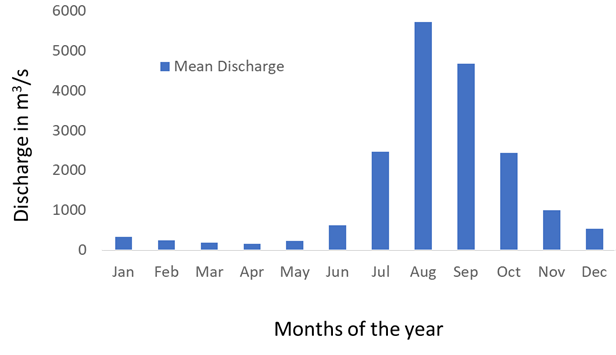
2.2.The Blue Nile Similarly, Fig.3. Shows hydrograph showing stream discharge of Blue Nile River. Blue Nile River systems encompasses rivers coming from western, west central and central highlands of Ethiopia’s various regional states. Major tributaries are Abbay, Jamma, Muger, Guder, Didessa, Beles, and Dabus rivers. Abbay River’s origin is Lake Tana, Amhara regional state, while Beles river also originates near Dangur woreda west of Lake Tana. Jamma, Guder and Muger rivers origins from the highlands of central Oromia, whereas Didessa river originates in Gomma area in the western highlands of Oromia; and Dabus river rises from around border of Benishangul-Gumuz and Oromia regional states near Asosa. The annual precipitation of rainfall for this Blue Nile catchment is averaged around 1212 mm/year. On average, this rainfall generates a Blue Nile river at streamflow rate up to 9408 m3/s and on average 1,548 m3/s, which is equivalent to 300 BCM and 54.4 BCM per year; respectively. Eighty-eight percent of this discharge occur between July and November. April is the driest month with the discharge rate of 155 m3/s, and August is the wettest month with m3/s discharge.
Fig.3. Hydrograph showing stream discharge of Blue Nile (Source: University of New Hampshire - Global Runoff Data Centre) 2.3.The Baro-Akobo-Sobat Sobat river system is consisted of Boro, Gile (Bako) and Akobo rivers originating in the southwestern Ethiopian highlands. Baro River comes from the southwestern highlands, east of Metu-Illubabor; whereas Akobo and Gile (Bako) rivers originate near Mizan Teferi, the administrative center of Bench Maji, the SNNRS. This region receives a year-round distributed mean annual precipitation of 1,338 mm per year. It is the wettest sub-basin of Ethiopia’s Nile sub-basin. Consequently, it generates rivers’ having the evenly distributed discharge throughout the year. Except for between March and May, the remaining months are, relatively, evenly wet. In general, April is still the driest month with the discharge rate of 100 m3/s, whereas October is the wettest month with 768 m3/s discharge. The average annual streamflow discharge of streamflow rate up to 680 m3/s and on average, 412 m³/s, which is equivalent to 21 BCM and 13.6 BCM per year; respectively. On the other hand, Egypt is not losing significant water through stream outflow. According to Zahran and Willis (2008), Nile River is the only year-round river in Egypt. However, several ephemeral rivers or wadis such as Wadi Abbad, Shait, and El-Kharisub are draining seasonal flood into the Nile River. Nile River branches out at Nile delta before draining into Mediterranean Sea. Studies (e.g., Bouraoui, et al., 2010) estimated that on average only around 13000 m³, equivalent to 0.000013 BCM of water, is discharged into Mediterranean Sea.
Fig.4. Hydrograph showing stream discharge of Sobat River (Source: Nile Basin Water Resources Atlas) Generally, Ethiopia’ Nile sub-basin annually experiences water losses in the form of surface water outflow. It loses 12.8 BCM of water through the Tekeze-Atbara River; 54.4 BCM of water through Blue Nile River, and 13.6 BCM of water through the Baro-Akobo-Sobat River. These sums up to 81 BCM of water leaving Ethiopia, without including ephemeral rivers that never leave the country and yet drains out the watershed. Blue Nile River is the dominant pathway through which most rainfall water exits Ethiopia’s sub-basin. It accounts for 67% of water outflow, while the Baro-Akobo-Sobat River accounts for 17% is and Tekeze-Atbara River accounts for 16%. In other words, outflow loss through Blue Nile River is 300% higher than Baro-Akobo-Sobat River and 325% higher than Tekeze-Atbara River. The loss through the Baro-Akobo-Sobat River is in turn 6.3% higher than the loss through Tekeze-Atbara River. In general, Egypt’s sub-basin loss of 0.000013 BCM of water is not significant compared to Ethiopia’s 81 BCM loss of water or the 84.6 BCM of water the sub-basins gained as hydrologic input from Ethiopia’s loss. 3. Conclusion The comprehensive assessment of sub-basins’ water loss through stream outflow has shed more lights on the resultant water resources of the two countries. On average, Ethiopia’s Nile sub-basin loses 81 BCM of water via surface water outflow every year, while Egypt’s sub-basin is losing none. Therefore, the perception of Ethiopia’s plentiful water resources defined based on the rainfall data alone, without accounting this kind of basin's loss is inconclusive. Ironically, the unaccounted Ethiopia’s water loss through stream water outflow is almost the same unaccounted water gain for Egypt‘s Nile sub-basin via stream water inflow. The tragedy, nonetheless, is not the Egypt’s deceit and untenable propaganda. It is the international communities and financial institutions rash to decry Ethiopia’s right to use Nile water resources, without any effort to scientifically authenticate the disinformation.
References: Berhanu, B., Seleshi, Y., & Melesse, A. M. (2014). Surface water and groundwater resources of Ethiopia: potentials and challenges of water resources development. In Nile River Basin (pp. 97-117). Nile Basin Initiative (2016-2017) Nile Basin Water Resources Atlas. http://atlas.nilebasin.org/ Water Systems Analysis Group (2014) Global Runoff Data Center river discharge database, University of New Hampshire, http://www.grdc.sr.unh.edu Zahran, M. A., & Willis, A. J. (2008). The vegetation of Egypt (Vol. 2). Springer Science & Business Media.
|